![](/images/other/stat-length.png)
![Trail Walking Les Estables - Mont Mezenc - Photo](https://media.geolcdn.com/t/1900/400/ext.pjpeg?maxdim=2&url=https%3A%2F%2Fstatic1.geolcdn.com%2Fsiteimages%2Fupload%2Ffiles%2F1553511878bg_sport_marche.png)
Mont Mezenc
rigol05
User
![Length](/images/other/stat-length.png)
Length
7.4 km
![Max alt](https://static1.geolcdn.com/siteimages/upload/files/1508320355ic_sort_altitude_max_24dp.png)
Max alt
1740 m
![Uphill gradient](https://static1.geolcdn.com/siteimages/upload/files/1508320355ic_sort_den_pos_24dp.png)
Uphill gradient
325 m
![Km-Effort](/images/other/stat-length.png)
Km-Effort
11.7 km
![Min alt](https://static1.geolcdn.com/siteimages/upload/files/1508320355ic_sort_altitude_min_24dp.png)
Min alt
1510 m
![Downhill gradient](https://static1.geolcdn.com/siteimages/upload/files/1508320355ic_sort_den_neg_24dp.png)
Downhill gradient
325 m
![Boucle](https://static1.geolcdn.com/siteimages/upload/files/16400158638029165_repeat_loop_refresh_sync_direction_icon.png)
Boucle
Yes
Creation date :
2017-07-06 00:00:00.0
Updated on :
2017-07-06 00:00:00.0
![Walking](https://static1.geolcdn.com/sitytour/trail-icons/101.png)
2h25
Difficulty : Medium
![Scan this QR Code to open this trail in the SityTrail application](https://capi.geolives.com/qq0zvz2zws4bq2lad0pu/sitytour/trails/779450/qr.png?size=200)
FREE GPS app for hiking
About
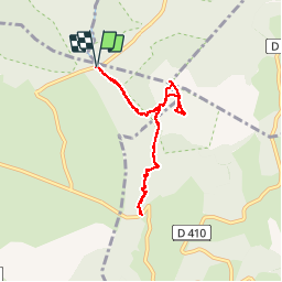
Trail Walking of 7.4 km to be discovered at Auvergne-Rhône-Alpes, Haute-Loire, Les Estables. This trail is proposed by rigol05.
Description
Séjour Ht.Loire sortie du 21/06
Départ croix de Peccata, croix de Boutières, sommet du Mézenc.
Erreur de circuit, A/R croix de Boutières puis sommet du Mézenc. Très gros orage de grêle pour finir
Positioning
Country:
France
Region :
Auvergne-Rhône-Alpes
Department/Province :
Haute-Loire
Municipality :
Les Estables
Location:
Unknown
Start:(Dec)
Start:(UTM)
593019 ; 4974277 (31T) N.
Comments
Trails nearby
![Trail Mountain bike Les Estables - Site VTT FFC du Mézenc et de la Loire sauvage - Circuit n° 04 - Tour du Mont Alambre - Photo](https://media.geolcdn.com/t/375/260/ext.jpg?maxdim=2&url=https%3A%2F%2Fservices.sitytrail.com%2FGeolivesWS%2FDownloadMedia.ashx%3FTrailID%3D107489%26Media%3D12434_3.jpg)
![Mountain bike Mountain bike](https://static1.geolcdn.com/sitytour/trail-icons/202.png)
Site VTT FFC du Mézenc et de la Loire sauvage - Circuit n° 04 - Tour du Mont ...
Mountain bike
Medium
(1)
Les Estables,
Auvergne-Rhône-Alpes,
Haute-Loire,
France
![](/images/other/stat-length.png)
8.6 km | 11.9 km-effort
1h 0min
![](https://static1.geolcdn.com/siteimages/upload/files/16400158638029165_repeat_loop_refresh_sync_direction_icon.png)
Yes
![Trail Mountain bike Les Estables - Site VTT FFC du Mézenc et de la Loire sauvage - Circuit n° 07 - Boucle en foret domaniale - Photo](https://media.geolcdn.com/t/375/260/ext.jpg?maxdim=2&url=https%3A%2F%2Fservices.sitytrail.com%2FGeolivesWS%2FDownloadMedia.ashx%3FTrailID%3D107492%26Media%3D12437_2.jpg)
![Mountain bike Mountain bike](https://static1.geolcdn.com/sitytour/trail-icons/202.png)
Site VTT FFC du Mézenc et de la Loire sauvage - Circuit n° 07 - Boucle en for...
Mountain bike
Difficult
(1)
Les Estables,
Auvergne-Rhône-Alpes,
Haute-Loire,
France
![](/images/other/stat-length.png)
19.9 km | 26 km-effort
2h 0min
![](https://static1.geolcdn.com/siteimages/upload/files/16400158638029165_repeat_loop_refresh_sync_direction_icon.png)
Yes
![Trail Walking Les Estables - Mont Mezenc - Photo](https://media.geolcdn.com/t/375/260/ce0fbf1f-346a-43be-bffd-dfd03dc61c12.jpg&format=jpg&maxdim=2)
![Walking Walking](https://static1.geolcdn.com/sitytour/trail-icons/101.png)
Mont Mezenc
Walking
Medium
(1)
Les Estables,
Auvergne-Rhône-Alpes,
Haute-Loire,
France
![](/images/other/stat-length.png)
13.8 km | 19.9 km-effort
4h 35min
![](https://static1.geolcdn.com/siteimages/upload/files/16400158638029165_repeat_loop_refresh_sync_direction_icon.png)
Yes
![Trail Walking Borée - Le tour du Mont Mézenc en Ardèche - Photo](https://media.geolcdn.com/t/375/260/970aece0-8ccf-44ea-bc9f-1d6489c7e0aa.jpg&format=jpg&maxdim=2)
![Walking Walking](https://static1.geolcdn.com/sitytour/trail-icons/101.png)
Le tour du Mont Mézenc en Ardèche
Walking
Medium
Borée,
Auvergne-Rhône-Alpes,
Ardèche,
France
![](/images/other/stat-length.png)
16.4 km | 23 km-effort
4h 21min
![](https://static1.geolcdn.com/siteimages/upload/files/16400158638029165_repeat_loop_refresh_sync_direction_icon.png)
Yes
![Trail Walking La Rochette - Le tour du Mont Signon au départ de la chambre d'hôtes La retrouvade - Photo](https://media.geolcdn.com/t/375/260/a743c4a1-06ad-43d0-8b82-bee213f09387.jpg&format=jpg&maxdim=2)
![Walking Walking](https://static1.geolcdn.com/sitytour/trail-icons/101.png)
Le tour du Mont Signon au départ de la chambre d'hôtes La retrouvade
Walking
Medium
La Rochette,
Auvergne-Rhône-Alpes,
Ardèche,
France
![](/images/other/stat-length.png)
18.8 km | 27 km-effort
4h 47min
![](https://static1.geolcdn.com/siteimages/upload/files/16400158638029165_repeat_loop_refresh_sync_direction_icon.png)
Yes
![Trail Walking Les Estables - Mont Mezenc Tour et sommet - Photo](https://media.geolcdn.com/t/375/260/fadc45c1-ba83-4e9a-a452-756f5fd46c63.jpg&format=jpg&maxdim=2)
![Walking Walking](https://static1.geolcdn.com/sitytour/trail-icons/101.png)
Mont Mezenc Tour et sommet
Walking
Medium
(1)
Les Estables,
Auvergne-Rhône-Alpes,
Haute-Loire,
France
![](/images/other/stat-length.png)
13.7 km | 20 km-effort
4h 36min
![](https://static1.geolcdn.com/siteimages/upload/files/16400158638029165_repeat_loop_refresh_sync_direction_icon.png)
Yes
![Trail Walking Borée - 2023-01-26_07h29m20_Tour Mézenc 17km.gpx.xml - Photo](https://media.geolcdn.com/t/375/260/92d24228-4d9c-4ba3-b5e5-3f7d7227fc7d.jpg&format=jpg&maxdim=2)
![Walking Walking](https://static1.geolcdn.com/sitytour/trail-icons/101.png)
2023-01-26_07h29m20_Tour Mézenc 17km.gpx.xml
Walking
Difficult
Borée,
Auvergne-Rhône-Alpes,
Ardèche,
France
![](/images/other/stat-length.png)
18.2 km | 27 km-effort
6h 5min
![](https://static1.geolcdn.com/siteimages/upload/files/16400158638029165_repeat_loop_refresh_sync_direction_icon.png)
Yes
![Trail Walking Saint-Clément - Circuit près de Fay sur LIGNON - Photo](https://media.geolcdn.com/t/375/260/4a4235b9-b681-43e5-9797-9f3a15ca73b3.jpg&format=jpg&maxdim=2)
![Walking Walking](https://static1.geolcdn.com/sitytour/trail-icons/101.png)
Circuit près de Fay sur LIGNON
Walking
Difficult
Saint-Clément,
Auvergne-Rhône-Alpes,
Ardèche,
France
![](/images/other/stat-length.png)
10 km | 12.3 km-effort
2h 27min
![](https://static1.geolcdn.com/siteimages/upload/files/16400158638029165_repeat_loop_refresh_sync_direction_icon.png)
No
![Trail Walking Les Estables - Circuit incluant le sommet du Mezenc - Photo](https://media.geolcdn.com/t/375/260/f9b8e22d-f239-491b-8f20-19a91b900080.jpg&format=jpg&maxdim=2)
![Walking Walking](https://static1.geolcdn.com/sitytour/trail-icons/101.png)
Circuit incluant le sommet du Mezenc
Walking
Medium
Les Estables,
Auvergne-Rhône-Alpes,
Haute-Loire,
France
![](/images/other/stat-length.png)
6.9 km | 10.2 km-effort
2h 52min
![](https://static1.geolcdn.com/siteimages/upload/files/16400158638029165_repeat_loop_refresh_sync_direction_icon.png)
No